
Development Land for Sale in Greater Napanee

Napanee Land
Two prime parcels · Greater Napanee, Ontario
Contact Jason
Official Plan approved by Lennox & Addington County · October 21, 2026

Over 100 acres inside Greater Napanee’s approved growth plan.

Two development parcels in Greater Napanee, minutes from Highway 401 and halfway between Kingston and Belleville.

Greater Napanee’s new Official Plan sets where the town grows for the next generation. Town Council adopted it on July 28, 2026, and Lennox & Addington County approved it unanimously on October 21, 2026. Both parcels are inside it: 88.5 acres in the Strategic Growth Secondary Plan Area, and 18.3 acres designated General Commercial along Highway 401.

Listed by Jason McDonald, Broker, Century 21 Lanthorn Real Estate Ltd., Brokerage.

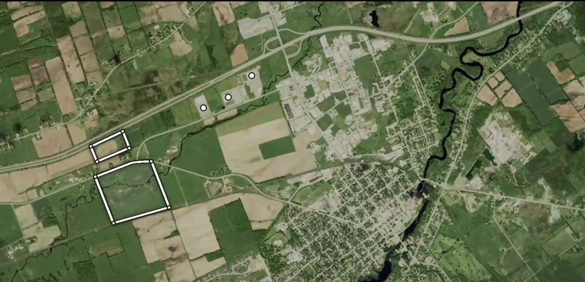
Satellite view of Napanee with both parcels outlined: the 88.5 acres between County Road 1 and the CN line, the 18.3 acres on Highway 401, the 401/Highway 41 interchange at top right and the town at right18.3 ACRESGENERAL COMMERCIAL · HWY 40188.5 ACRESSTRATEGIC GROWTH AREAHIGHWAY 401JIM KIMMETT BLVD401 · HWY 41 INTERCHANGE← BELLEVILLE · 40 KMKINGSTON · 46 KM →0500 m1 kmNDOWNTOWNWALMARTBEST & BASH ARENAHOME HARDWARE
Brick storefronts and a Canadian flag on Dundas Street in historic downtown Napanee
Historic downtown
Greater Napanee · Boundaries approximate · Imagery © Google
$88M
Wastewater plant expansion, in service in 2028
$575M+
Goodyear Canada’s investment in its Napanee plant
3
New arterial roads set by a completed Environmental Assessment
2 km
Along Jim Kimmett Boulevard to Highway 41, with the 401 interchange just beyond
The path to approval
Sept 2024
Environmental Assessment completed, recommending three new arterial roads
Mar 2026
County adopts its growth framework to 2051
July 28, 2026
Town Council adopts the new Official Plan
Aug 6, 2026
Province approves the County framework, now in effect
Oct 21, 2026
County approves the Town’s plan, unanimously
Next
Secondary planning sets land uses, densities and street patterns, with landowners taking part
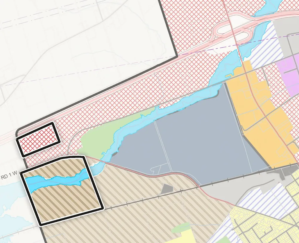
Excerpt of Schedule A, Land Use, Urban Area, of the Greater Napanee Official Plan, with the 88.5-acre parcel outlined in the Strategic Growth Secondary Plan Area and the 18.3-acre parcel outlined in the General Commercial designation on Highway 40118.3 ACRES88.5 ACRES401 · HWY 41
Schedule A excerpt · Town of Greater Napanee · Outlines added, approximate
On the Official Plan

Both parcels on the approved land use schedule

Schedule A of the new Official Plan places the 88.5 acres in the Strategic Growth Secondary Plan Area, at the western edge of the urban area between County Road 1 and the CN line. The 18.3 acres is in the General Commercial designation along Highway 401.

Strategic Growth Secondary Plan Area
General Commercial
Selby Creek Secondary Plan
The two parcels (outlines approximate)
For developers, builders and investors

The groundwork is done. The plan is next.

The steps that usually hold growth land back for years are already behind these parcels. Here is where they stand.

Designations settled
The County’s growth framework took effect in August 2026 and the Town’s Official Plan was approved on October 21. Under the current Planning Act, neither is open to third-party appeal.
Already inside the urban boundary
Both parcels sit within Napanee’s settlement area today. No boundary expansion or annexation stands between them and secondary planning.
Sewer capacity under construction
The $88M wastewater plant expansion is being built now. When it opens in 2028 it is estimated to add capacity for up to 4,000 homes and businesses.
Arterial roads defined
A completed Environmental Assessment fixes the arterial network through the growth lands, including a new County road with a CN rail overpass and a creek bridge.
Little competing supply
The plan directs future growth to two designated areas, and most of that land is closely held. No other holding of this size in them is on the market.
A voice in the secondary plan
The secondary plan sets land uses, densities and local streets. Owners in place when it begins take part in shaping it.
Still ahead: secondary planning, rezoning and servicing allocation, before development can proceed.

The offering · Development land for sale in Greater Napanee
Two separate listings: a Strategic Growth Area parcel and a Highway 401 commercial parcel.
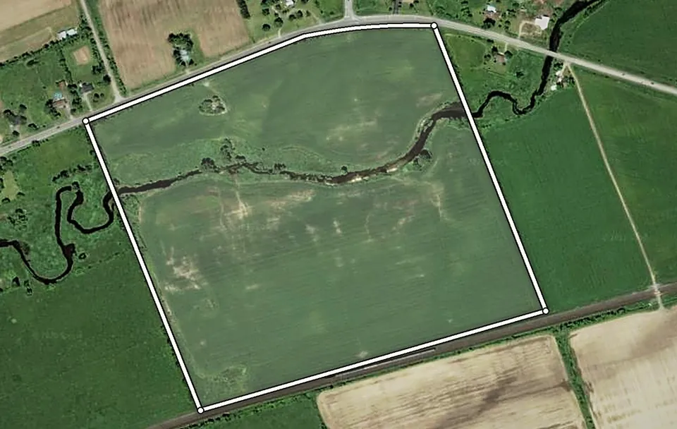
Satellite view of the 88.5-acre parcel outlined between County Road 1 and the CN rail line, bounded by a tree line on the west and the neighbouring field on the east, with the creek crossing it88.5 ACRESCOUNTY ROAD 1CN RAILcreek
Boundaries approximateImagery © Google
Strategic Growth Area · County Road 1

88.5 acres in the Strategic Growth Secondary Plan Area

$30,000,000

Greater Napanee has chosen where its next generation of growth goes, and these 88.5 contiguous acres are inside it. No other holding of this size in the area is currently offered for sale.

Designation
Strategic Growth Secondary Plan Area, Schedule A of the Official Plan
Roads
The EA’s Cherrywood Parkway to County Road 1 arterial alignment crosses the property
Land
Owner-farmed and in active production, with a creek through the property and frontage on County Road 1
Services
Not yet available; the $88M wastewater expansion, in service 2028, is estimated to add capacity for up to 4,000 homes and businesses

The secondary plan will set land uses, densities, local streets and servicing. Owners in place when it begins take part in that process. Secondary planning and rezoning come before development.

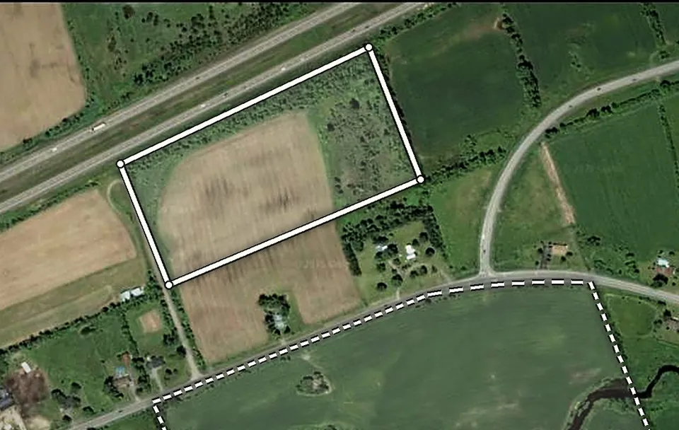
Satellite view of the 18.3-acre parcel outlined on Highway 401 between the side road and the next field, with Jim Kimmett Boulevard to the east and the 88.5-acre parcel dashed to the south18.3 ACRESHIGHWAY 401JIM KIMMETT BLVDCOUNTY ROAD 188.5 ACRES · ALSO FOR SALE
Boundaries approximateImagery © Google
General Commercial · Highway 401

18.3 acres with prime Highway 401 exposure

$10,000,000

Exposure like this is rare. The parcel sits on the outside of a long bend in Highway 401, Canada’s busiest highway, so it stays in full view of traffic in both directions. A side road runs along the west boundary, and the Jim Kimmett Boulevard retail corridor is next door.

Designation
General Commercial under the Official Plan approved October 21, 2026
Zoning
Future Development; the Town has budgeted a zoning by-law update to bring zoning in line with the new plan
Land
About 12 acres cleared and farmed, with the balance in open scrub
Services
Not yet available; municipal services exist in the Jim Kimmett corridor

MTO is studying Highway 401 improvements, including future widening. Buyers should confirm with MTO whether any property requirement affects the Highway 401 side of the parcel.

A closer look

Open land, approved for growth

From the air and from County Road 1
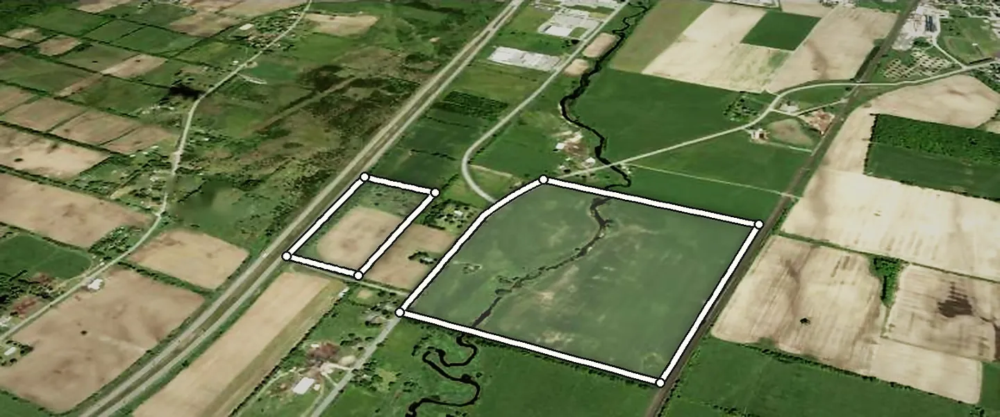
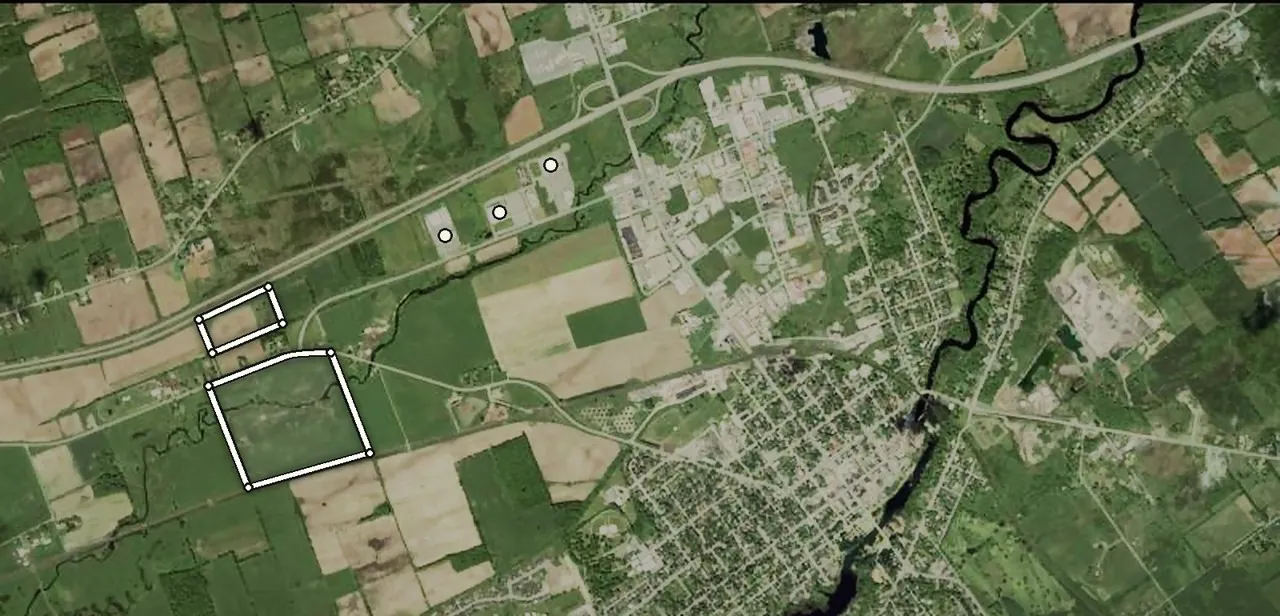
Aerial view looking northeast over both parcels: 18.3 acres on Highway 401 and 88.5 acres between County Road 1 and the CN rail line, with the creek crossing it18.3 ACRES88.5 ACRESHIGHWAY 401COUNTY ROAD 1JIM KIMMETT BLVDCN RAILcreek
Both parcels from the air, looking northeast · Boundaries approximate · Imagery © Google
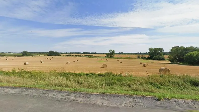
Round hay bales across the 88.5-acre field, seen from County Road 1 under a summer sky
88.5 acres · County Road 1 · Aug 2026
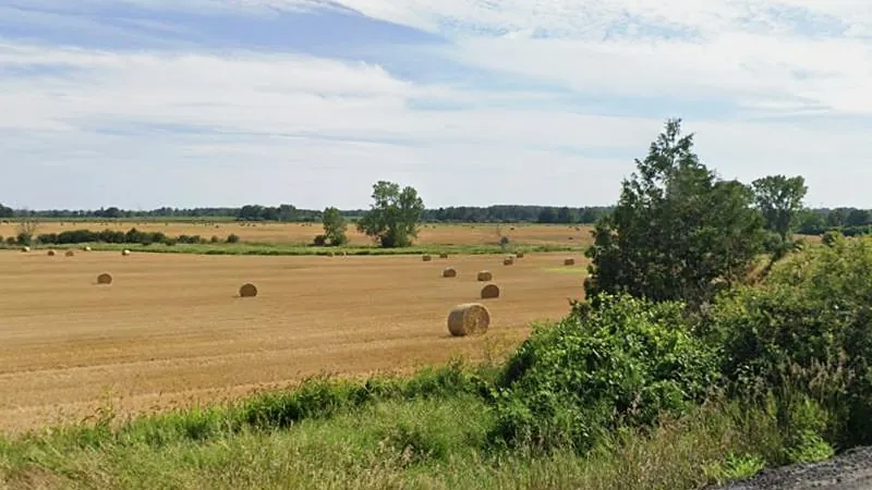
The 88.5-acre field from County Road 1, harvested with bales in rows and a tree line on the horizon
88.5 acres · County Road 1 · Aug 2026
Imagery © Google
The setting

The Town of Greater Napanee

A historic river town on Ontario’s busiest corridor.

Greater Napanee pairs small-town character with direct access to Highway 401. The historic downtown sits at the falls of the Napanee River, the Bay of Quinte is minutes away, and Kingston and Belleville are each within an easy commute.

In 2026 the Province approved the County’s growth framework to 2051, and the Town’s new Official Plan placed future growth on a short list of designated lands, these parcels among them. Goodyear is investing $575 million in its Napanee plant, announced in town with the Prime Minister and the Premier. An $88-million wastewater expansion is under construction, and a 545-home master-planned community is under way.

Corridor
Halfway between Toronto and Montreal on Highway 401, with the Highway 41 interchange about 2.5 km away by road
Cities
Kingston and Belleville both within an easy commute
Talent
A regional workforce, with Queen’s University, St. Lawrence College and Loyalist College nearby
Anchor
Goodyear Canada’s $575M modernization takes its Napanee workforce past 1,000
Underway
$88M wastewater expansion, a 545-home master-planned community, and MTO studies for Highway 401 improvements
Horizon
Kingston under study for a stop on Alto, Canada’s planned high-speed rail line